November 30, 1999
[1 2]

Both the Uplands Trail and the Rim Rock Trail were flanked by profusions of large sage bushes, serviceberry and blooming flowers, even in late summer. Both trails end at the park’s visitor center. From the center, the Oak Flat Trail winds through scrub oak, offering enticing glimpses into the canyon. The Uplands and Oak Flat Trails let the hiker experience the quiet, pungent, lush ecology of the high-altitude scrub oak forest that eventually spills down into the canyon. This summer in Colorado was unusually wet, and tall grasses sprouted on either side of the trails, with large mushrooms growing beneath. A dry, sage-laced breeze rustled over the plateau. The mornings we meandered along the trails, a spooky white mist rose from the river far below, adding to the enchantment of the rim.
To take the Gunnison Route down to the river, one must first obtain a backcountry permit, which involves listening to an explanation of the route from a ranger, who explained that the Tomichi Route is very rocky, mostly scree down to the water, while the Warner Route, the longest of the three south rim descents, is best suited for an overnight excursion. The Gunnison Route, the ranger noted, is the most popular route and is the easiest way down.
The ranger stressed the level of difficulty of the route, the need for good hiking shoes and plenty of water. Showing us photos of the route, we almost got the impression that the ranger was trying to talk us out of going down. Yes, it’s steep, you need good equipment and lots of agua. “Do you still want to take the route?” the ranger asked. After listening to the rap, the answer was an enthusiastic “hell, yes!”
Permit in hand, we began the descent by following the Oak Flat Trail. After passing a “River Access” sign, the trail soon disappears down the drainage. An 80-foot chain helps with a particularly steep part of the descent, and various wood and rock markers signal the way down through narrow alleys of loose rock, aspens and scrub oak.
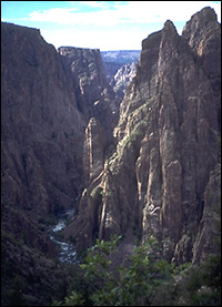
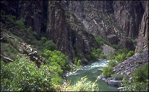
Slowly, the majestic canyon begins to reveal itself as the faint “roar” of the river becomes louder and louder. The hiker is advised to keep both hands free and make sure, solid steps as loose rock and a steep grade demand careful attention. Several fields of scree dot the drainage. Footholds are plentiful but precarious. It’s advisable to note landmarks and spires on the canyon walls across the river to help navigate on the return. Taking our time, the descent took us about two hours.
Once down at the water’s edge, a short jaunt upstream leads to a beautiful campground with several idyllic sites. This section of the Gunnison is designated as Colorado Gold Medal Waters, meaning large trout are prevalent.

Within 30 minutes of our arrival at the water’s edge, a windy rainstorm blew in from the south, making the ascent along slick, wet scree fields that much trickier. Climbing up out of canyon in the rain added another element of adventure to the trek, despite the fact we missed the chain on the way up and ended trailblazing up through the dense foliage of the hanging valley for the last few hundred yards.
There are many ways to enjoy the Black Canyon of the Gunnison, from the quiet trails of the South Rim to the several lookout points along the South Rim road, to actually descending down to the river.
Yet what took nature millions of years to create may be imperiled by a single act of Congress. The transformation of Black Canyon from sleepy national monument to marquee national park will surely draw more visitors, and it remains to be seen what the effect will be. Exactly why the change was made, except for a superficial feather in a Colorado U.S. Senator’s cap, is unclear to us.
But the sheer effort and sense of adventure needed to experience the Black Canyon makes this destination a memorable one.
Story and photos by David Iler
<– Return to Page 1
[1 2]